Western Express Day #19 Austin, NV to Middlegate, NV
Western Express Day #19
June 19 2021
Austin, NV to Middlegate, NV - 65 Miles
Start 6:20AM Finish 12:30PM
Ride Time: 5:38
Ascent: 2106'
Descent: 4172'
Tour Total Miles: 1267
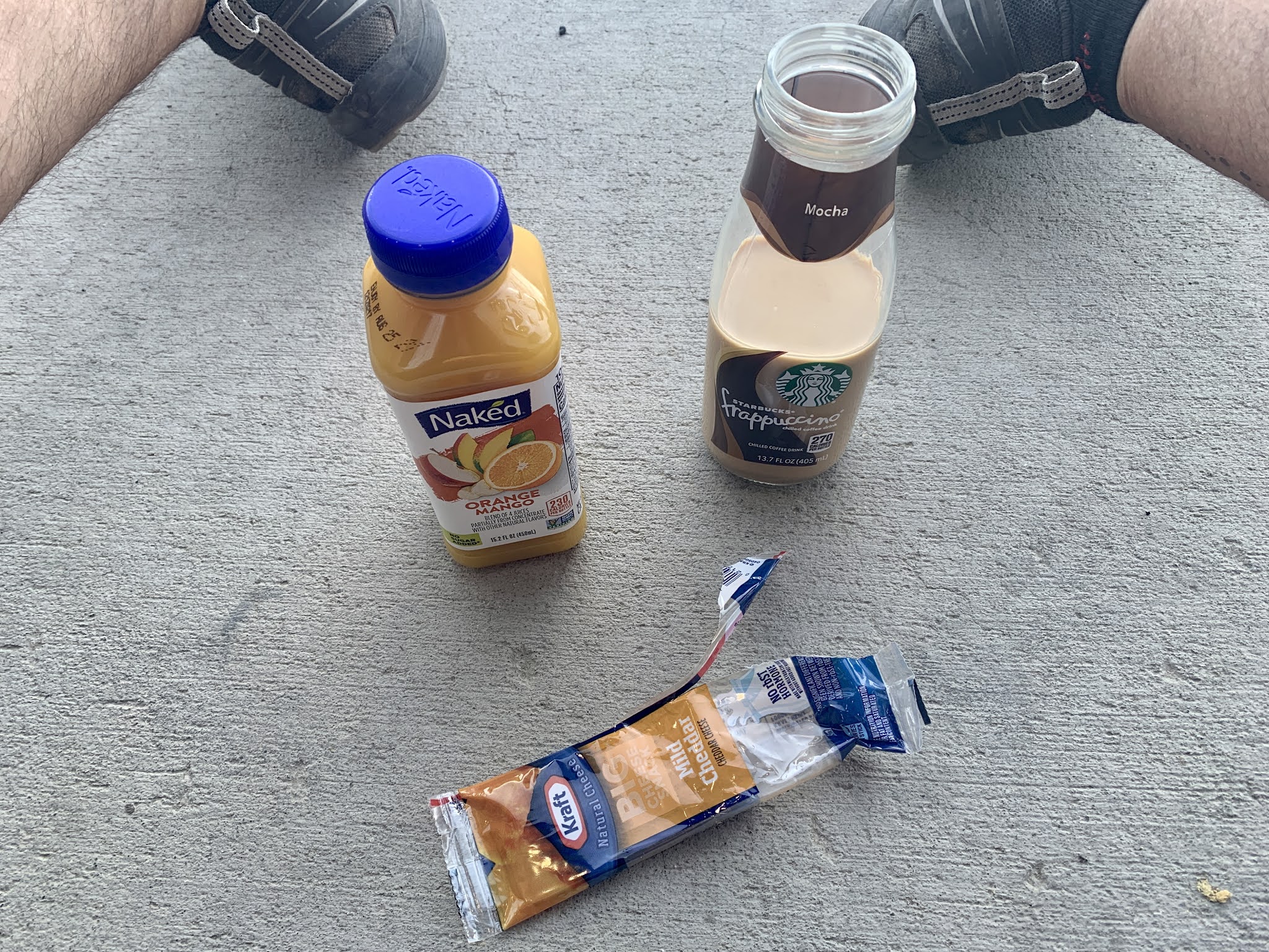
Last night I slept on the Austin Gridley Days stage in the City Park of Austin. I believe it was my third time sleeping on an outdoor stage in a city park while on a bike tour. It got chilly during the night and I slept in my silk liner and eventually used my sleeping bag. I hadn’t set up the tent fly. The park sprinklers where blasting in the morning and the stage had been a solid choice. I was now at level three. I was surrounded by Mormon crickets in dusty depressing Austin Nevada. That said, my nails were trimmed and my ears were swabbed. I stopped back at Champs and purchased a Starbucks Frappuccino, a mango orange juice, and a cheese stick. I took a birdbath in the restroom and filled my water bottles. I got back out on the road and finished my downhill off of Pinto pass, and then rode out into the valley.
The valley here had ripples. The road was straight and level but I was surrounded by undulations, which was a pleasant variation from the past few days. I departed US 50 to take the Carroll Summit alternate route. I turned left onto Nevada State Highway 722, and was surrounded by sage brush and faraway mountains. It was still chilly and I was wearing my sweater, cycling shorts, short-sleeve jersey, and helmet brim. I crossed a cattle grate into another open range.
I was on a long straight flat, and could see seven miles ahead to where the highway curved up towards the next pass. Yesterday Jessica had told me that there were only nine children in the Austin town school, and two of them were her boys. She’d never been on an airplane, and didn’t know how to ride a bicycle. Unlike Eureka, Austin had no vision to revitalize the town. Folks were were waiting for mining regulations to be loosened and the next precious metal boom. Aside from the gas station, Austin was a cash only town. The power here was geothermally generated.
I saw a large jackrabbit zip across the road. I passed verdant grass pastures on both sides of the road where I crossed over the Reese River, where there was a small stream of water. The sage brush returned along with it's wonderful aroma. Jessica had said that the yesterday’s haze was caused by western wildfires. There didn't appear to be any Mormon Crickets on the road this morning. I pulled over to flip my map panels and to remove my sweater. I was crossing a fifteen mile wide valley and headed towards the next range to the west. Once again there would be no services along today’s route. It was 64 miles to Middlegate, where there was camping, a store, and a bar. I had been given good reports about Middlegate from east-bounders.
I rustled some cattle that were on the road side of the fence and I corralled them towards an open field. I noticed a lone pronghorn against the barbwire on the right side of the road, and then I saw a few more. Suddenly I realized a huge herd on both sides of the highway. Then I saw another jack rabbit with it’s long erect ears.
The Mormon crickets returned, hopping like zombies all over the road and landscape. I was listening to a WFMU Nickel And Dime Radio with $mall ¢hange file on my iPod. I was headed up towards the first pass and trying to squish Mormon crickets, and was startled by a badger on the side of the road not six feet away. I think we were actually both startled, and I didn’t have time to take a photo.
I reached the summit of 6441’ Railroad Pass. There was no elevation sign and a giant mud flat appeared ahead in the valley. I saw another badger scurrying across the highway. I was riding through Smith Creek Valley and was surrounded by sagebrush and dirt. The mud flat was up against a large mountain range to the west, and it took me an hour to ride around it.
A motor vehicle passed me coming from the west. It was the first I’d seen on Highway 722. Then four motorcycles appeared from the east and passed me. I came to a homestead that I had been observing for over ten miles. There were several tall trees, a few houses, a large tank, and a number of vehicles. I suspected that at one point it had been a service station.
The highway then began to twist to the west, towards the next ridge. I passed the 'chain and snow tire required when flashing' sign. I stopped to take a photo of a road sign and startled a jack rabbit that darted out from behind a bush. I was passed by a second eastbound motorist and then another westbound motorist. This was truly a lonely road. Another motorist passed me going west. The climbing began up through a narrow canyon, and I saw several old mineshaft remains.
I was following Campbell Creek to my left. I found a shady spot underneath some bushes and there was a nice fragrance in the air. I sat down on a rock to drink some water and apply sunscreen. I was startled to realize dozens of large red ants crawling all over my feet and legs. I jumped up and abbreviated my break. A pick-up truck passed me coming from the west. It was towing four Porta-Potty‘s in a trailer. I spotted a group of cattle in a small pasture to the left.
As I approached the top of the ridge I noticed the burn areas that Jessica had mentioned yesterday. I reached the summit of 7452’ Carol Summit and crossed the Churchhill County line. There was no elevation sign. A pick-up truck from the west passed me. I sped down a steep twisty downhill, winding through the narrow canyon on the west side of the ridge. I was riding through Oad Canyon. I was passed by a white Jeep coming from the east. The valley opening here was different, with undulations and not a great wide expanse. The terrain continued to roll, and I rounded a grouping of smaller ridges. I crossed over Buffalo Creek and passed the homestead of Eastgate. It was indicated on my map without a population, and was essentially a group of trees and buildings. It was a little bit before noon and I was eight miles from my destination.
I entered another vast wide-open valley, and five miles later I re-joined US 50. I was back on the main route, and I no longer had the road to myself. I was experiencing a head wind and it was beginning to get hot. Finally I took a left on State Highway 361 and headed a half-mile off route to Middlegate Station, my destination for the day.
I noticed trees, campers, a small honky tonk hotel, a bar, and golf carts. This place was an oasis filled with nomads, and the bar was hopping. There were dollar bills with signatures stapled to the ceiling. I drank numerous Pepsi’s on ice and took the Monster Burger challenge. Had I been able to finish it, I would have received a free t-shirt. I hadn’t essentially eaten since yesterday's lunch, and I gave it a good try. I didn’t need to prove anything, and didn’t necessarily want to travel with a t-shirt that I’d probably never wear.
I worked on today’s report, and began drinking pints of 805. I met westbound cyclist Kyle who was riding from Illinois. He had suffered mechanical issues and had to hitch a ride to Reno for repairs. He had a plane to catch in San Francisco and was behind schedule. He mentioned that he had been sleeping in the desert between towns. He would hang out in town during the heat of the day, and then pedal twenty to thirty miles after it cooled down. He was the first westbound cyclist that I had met on the tour.


I wondered if you'd try for the Middlegate Monster T-shirt! It's such a cute burger...
ReplyDelete