Western Express Day #9 Natural Bridges Campground, UT to Hanksville, UT
Western Express Day #9
June 9, 2021
Natural Bridges Campground, UT to Hanksville, UT - 100 Miles
Start 6:36AM, Finish 4:35PM
Ride Time: 7:51
Ascent: 4080'
Descent: 6180'
Tour Total Miles: 601
I slept well last night in my tent, in site number three at Natural Bridges National Monument. Last evening I had relished my freeze-dried Pad Thai so much that I tried to squeeze every last bit out of bag. I could have easily eaten the other freeze-dried meal stowed in my rear right pannier. After dinner, I sat at the picnic table and gazed up at the amazing stars. There was no night pollution here, and the atmospheric conditions were perfect. I didn’t see any stars or planets that I recognized, and I couldn’t see the Milky Way. There was still light in the western sky and I was tired. A couple in the adjoining site was giggling in their tent. Were they having sex? Because that’s what it seemed like. As I was packing up and preparing for the tomorrow's ride I noticed a loose bolt on my front right rack. The bolt had almost completely backed itself out. I attributed it to the rocking motion of the extra water bottles that I was carrying strapped sideways to my front panniers. That, and I must not have tightened it enough at the beginning of the trip. I went around and made sure that all my bolts were tight. I also had a large hole in my right sock in front of my big toe, which eventually needed to be mended.
I woke up around 6 AM with the light coming into my tent. I got up and packed up my camp. I stuck my extra 1.5 liter water bottles inside my front panniers instead of strapped to the tops like yesterday. I rode back to the visitor center and filled my two empty frame mounted bottles. I had more than enough water to get to Hanksville. It was a long slow climb getting out of the campground. The air was cool and I was wearing my cycling shorts, short-sleeve jersey, and cycling sweater. These were not the first natural bridges that I’d seen on a bike tour. On the Trans Am I had stopped at Natural Bridge in Virginia with Stephen G. Unlike the pristine spans out here in Utah, the Virginia version had a roadway over the top which I had crossed on my bike.
I was a feeling a little hungry this morning. I had a bag of cashews and a tiny bit of granola in my front left pannier. In my rear left pannier I still had a large bag of granola and another freeze-dried meal. The air was cool and there were a few wispy clouds on the horizon. The sun was blazing. I took a right on State Highway 95 aka The Trail of the Ancients. Ostensibly it was going to be downhill all the way to Hite.
The mile markers were counting down to Hanksville, and I had 87 more to go. I passed ginormous rock formations that resembled classical western temples. There were incredible mesas and bluffs. I came to the intersection of State Highway 276. It was 7:38AM and Hite was another 35 miles ahead. Hanksville was 84 miles in the distance.
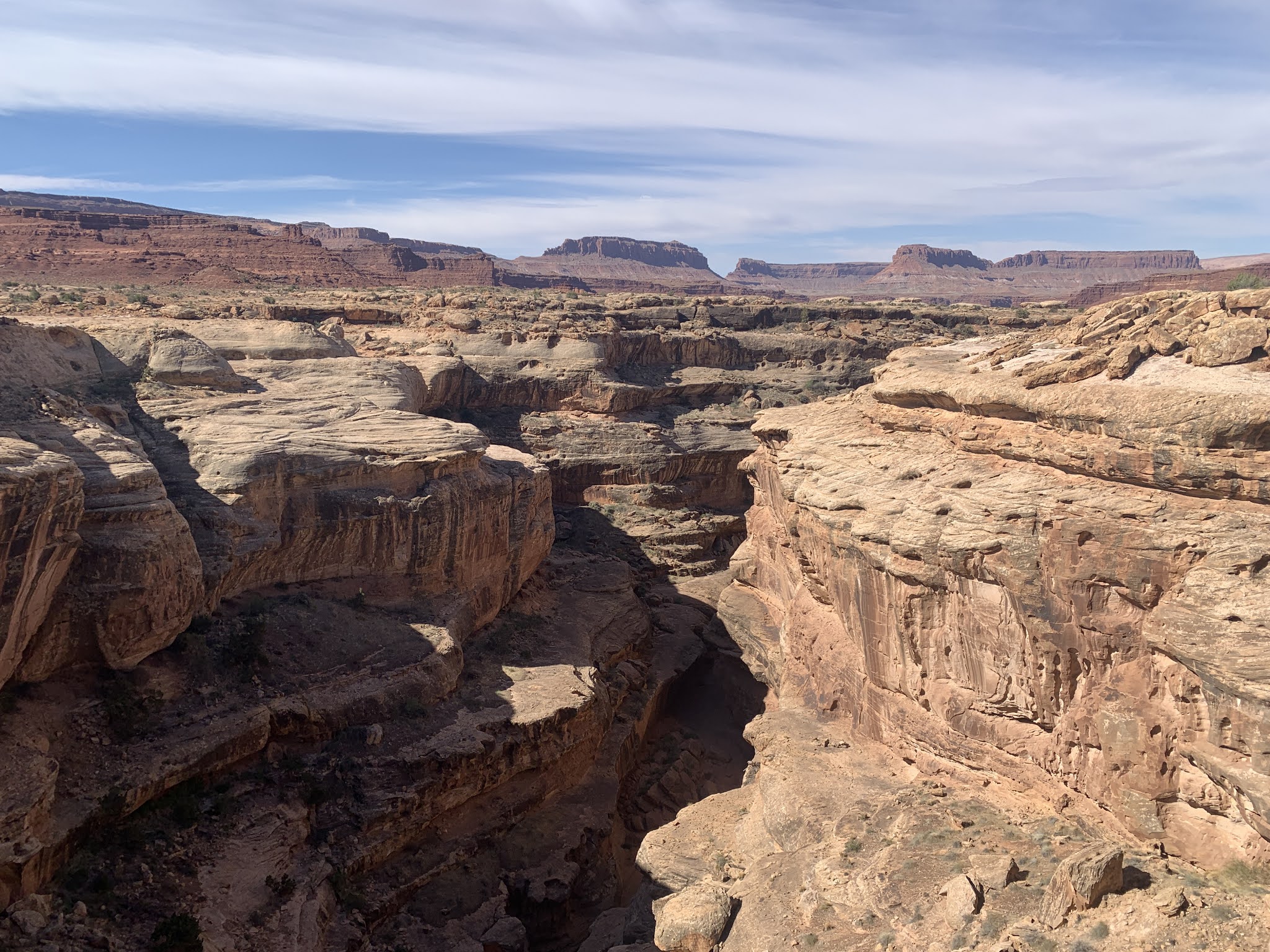
I rode to the left of 7753’ Moss Back Butte and admired the rock formations and scraggly green bushes. To the right I could still see Bears Ears in the distance. Highway 95 passed through a sliver of Natural Bridges National Monument and I could see the curvy white windswept no-man’s land canyon system that I had visited yesterday. I passed Cheese Box Butte, which clearly stood out and had an appropriate name. Continuing through White Canyon I was amazed by the red rock formations which seemed like Egyptian reliefs. On the other side of the valley, the curvy cut white stone seemed otherworldly.
Motor traffic was very sparse. A white van coming from the other direction slowed down, and I could see that the driver was giving me a thumbs up. In the middle of nowhere I passed the Fry Canyon Lodge. There had been a uranium mining boom here in the 1950’s and the lodge had closed in the early 2000’s. At mile marker 68 fresh black, glistening tar and chipped pavement appeared along with new traffic markings.`I started seeing figures In the rock formations. One looked like an eagle with it’s beak projected and it’s wings tucked. A bearded figure was standing besides it.
At mile marker 65 I stopped to switch my map panels, remove my sweater, add sunscreen, and put on my UV protectors. Right as I was applying chamois butter a motorist drove bye. I was seventeen miles from the store at Hite. By 9:15AM I was starting to get hot. I had ten more miles. At some point I realized that the pavement was no longer new. It was all good and there was hardly any motor traffic. There were no fences alongside the road, as it was an open range. In my opinion there wasn’t much for animals to eat around here. I only saw hardy grass stalks and scraggly brush. The new chip seal began again at mile marker 57, and at mile marker 55 it ended. I crossed over a deep canyon with smooth white rock formations below, similar to what I had seen at Natural Bridges. I was seeing lots of cow patties, and they appeared recent.
I took a left and went a mile off route to the small recreational area called Hite. The store was open and the proprietor Katy a.k.a. cock-a-doodle-doo was a unique good-humored person who had been around the block a couple of times. She had lived in Chicago and Denver, and had been here a few years. As for food in the store, there wasn’t much to choose from. I got a microwave burrito, a jar of applesauce, and two pink Gatorade‘s. I was able to tap into the WiFi and upload yesterday’s report. Katy warned me that it would be rough going climbing out of the canyon on the other side. After that, ostensibly, it would be an easy ride all the way to Hanksville. It was 11:15AM when I left Hite, and it was considerably hotter. I was halfway done with 48 miles to go.
I knew that Lake Powell levels were low and Katy had told me that the river was re-creating itself. Many of the stone shelves were collapsing. She said that the lake’s deepest point at Hite was still 35 feet. I rode down into the valley and crossed the Colorado river on a steel arch bridge. The river was deep down in the canyon underneath. The muddy brown flow was the first water feature I’d seen in days. I entered Garfield County. I passed a small airstrip for Glen Canyon National Recreation Area, which was essentially a strip of asphalt and a windsock. I rode around a big bend and passed the Dirty Devil River, which was basically a narrow band of brown mud and puddles.
Katy and another store patron had warned me about the climb getting out of the valley on the other side. I had seen the cut from from across the river, and knew that it would be steep. The only thing worse than a steep climb is a steep climb combined with a headwind. The only positive was that the breeze cools down the cyclist. I finally climbed my way up out of the steep cut. I was at mile marker 41 and it was 12:41 PM. I could see the Colorado River to the left. I was following the North Wash up a long canyon. The sky was hazy and it was protecting me from the sun.
I stopped at the Hog Springs picnic area in the middle of a brown canyon. It had a pedestrian suspension bridge over the rut. I found a picnic table in the shade where I mended my sock and flipped my map panel. I met a motorcyclist from Sacramento who said he had noticed my bright fluorescent brim first thing on the highway. That was good to know. When I left it was sunny again.
I rode by Turkey Knob on the right with red-colored rock formations. The stone to the left was light brown in color. A motorcyclist was parked along the side of the highway at mile marker 28. I asked if he was all right, and he replied that he was good. It was a long slow climb and I was traveling ten miles an hour, which wasn’t fast enough to keep the deer flies away. At mile marker 26, I passed the junction for State Highway 276. I once again had a brand new tar and chip surface.
Beautiful orange rock formations appeared to my right. The valley to my left was wide open with a tall ridge in the distance and a little snow on top. It was overcast and I was benefiting from a tail wind. The new highway tar and chip seal began again. The road ran up against smooth orange rocks to the right.
I was using the mile markers, map, odometer to calculate my countdown. I was hoping that there would be cold beer in Hanksville. I had heard that some places in Utah were dry. I passed Poison Spring Benches to the left, and was still climbing. I had a good shoulder the whole ride today. I was still seeing cow pies. Andy from the TransGrang told me that when he came through this way, he rode through a ginormous herd of sheep. I enjoyed a nice downhill cut through the rock.
I crossed the Wayne County line and was sixteen miles from my destination. I was surrounded by dirt, sand, rocks, and sage brush. A silver pick-up truck pulled over and the woman in the passenger seat asked if I was OK. I was on a downhill on my final stretch. I supposed a cold beer would have been nice. Motorist friends reading this should keep a small cooler of cold beer in the car to give to cyclists.
The last twelve miles into Hanksville were downhill and I was cruising at 21 miles an hour. I was once again able to get phone service. It would be my first century on the tour. When I had created my itinerary I had miscalculated this stretch at 83 miles. I heard from plant guy on Crazy Guy. The flowering cactus photos that I posted yesterday were the same species, Plains Prickly Pear.
I passed the Hanksville welcome sign. The town had a population of 219. I went straight to Outlaw’s Roost, and was expecting a dark, smoke-filled room filled with cowboys and bandits. I was surprised to find a clean and family oriented restaurant. Because of strict Utah alcohol laws, I had to order the Dos Equis one at a time. I munched down two servings of chips with some of the best salsa I’ve ever had. The menu seemed complicated so I ordered the same burrito as the person ahead of me. It was delicious and I was finally sated.
I cycled over to Duke’s Slickrock Campground and RV park. I set up my tent in a patch of thick green grass and then took a shower. I edited this report in the wind and drank a few more beers, while sitting at a table in front of the bathroom building.


Comments
Post a Comment