Western Express Day #8 Monticello, UT to Natural Bridges Campground, UT
Western Express Day #8
June 8, 2021
Monticello, UT to Natural Bridges Campground, UT - 61 Miles
Start 6:23AM, Finish 5:27PM
Ride Time: 6:47
Ascent: 4012'
Descent: 4539'
Tour Total Miles: 491
I slept well in my tent pitched besides the “K” LINE storage container in the back of the Old West RV Park in Monticello. It was chilly when I got up, and I put on my sweater before I left the tent. A pick-up truck pulled in to the RV park with its headlights beaming straight at me while it’s engine grumbled. Then the dog in the adjacent cabin started barking. It was good that I got up when I did. Last night after I finished editing yesterday’s report, I sat at the picnic table and drink cold bottles of Sam Adams beer. There was still light in the western sky, and it was blissfully quiet.
This morning it was a pretty quick pack up, and I was on the road by 6:23AM. It would be a twenty mile ride to Blanding, and I ate a banana before departing. The sun was just coming up over the horizon like a blood orange orb. I was wearing my cycling shorts, short-sleeve jersey, sweater, and rain jacket. The air was cool. The wind wasn’t bad yet but it was forecast to get strong as the day progressed. It would once again be coming from the south, and my first segment to Blanding was a due south heading.
I passed Devils Canyon and the Recapture Reservoir. I had sent Philip a selfie of Melissa and myself yesterday. He reported back that he would be crossing the Missouri state line tomorrow. Kraig Pauli was currently leading the TransAm Race. He had already covered 605 miles and was almost to the Idaho border.
As I was coming into Blanding I saw a billboard advertising ‘Yaks Cafe serving breakfast’. The parking lot was packed so I stopped. I ordered the Truckers Special- three eggs over-easy, four strips of bacon, one sausage patty, two slices of ham, hash browns, whole wheat toast, two pancakes, and an orange juice. I was preparing myself for two full days without services. I removed my rain jacket and went to the Maverik station where I purchased two 1.5 liter bottles of water. I strapped the bottles to the top of my front panniers.
Blanding's welcome sign had read, ‘City of Blanding - Basecamp to adventure’. The town had a population of 3375 and it’s elevation was 6,106'. I rode through the business district, and noticed numerous signs for burritos and tacos. I also saw a few Native American trading posts. There were sprinklers watering people’s green lawns. By 9AM it was starting to get windy. It was coming from the south like yesterday. I saw a sign that read, ‘Roadwork Next 6 Miles’.
I saw dozens of prairie dogs scampering into their roadside tunnels beneath the scrub. I rode down US 191 past the airport, where a billowing American flag confirmed that the wind was strong and coming out of the south. The highway took a big U-turn heading back north, and for a moment I had a tailwind. I took a right on State Highway 95. A notice on my map said ‘Very limited services next 125 miles’. I believed that I was prepared.
I cycled through open range with scrub and brown dirt. There was very little out here. I descended down into a valley with large bluffs and brown rock formations. I stopped to remove my sweater, lathered myself with sunscreen, and slipped on my UV arm covers. I crossed several cattle grates which spanned the highway. Those things freak me out if I think about it. I noticed dry cow patties on the road. I barreled down into a canyon and my top speed was 35 miles an hour. The wind was causing my brim to bounce all over my head, and it was hard to concentrate on the road. The wind was strong on the ridges and calm in the valleys. I was heading south once again.
I was surrounded by green prickly trees and bushes, and red dirt. Up ahead was a hilltop with yellow and light-brown tones. The highway had recently been paved and the surface was jet black with brand new white and yellow pavement markings. There was nothing around for miles. An occasional motor vehicle would pass.
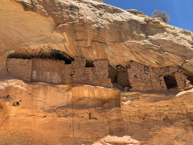
I came to a sign announcing the Butler Wash ruins. I parked my bike and walked over a mile through a dusty reddish-brown canyon planted with cottonwood trees. Small brown lizards were scampering everywhere. I found a cliff overhang that I figured was the site. It reminded me of a miniature version of Cave in Rock along the Ohio River. As I returned to my bike I ran into a few families who were also hiking to the ruins. Jared was from Monticello and his wife was from Blanding. Their friends were from Northern Utah. Jared told me that I hadn’t gone to the right place, and said that it was worth it. Perhaps the authorities keep it confusing on purpose. I followed them and never would’ve found it on my own. The Cottonwood trees produced a billowy white cotton-like substance that was mixed with the dust on the ground. I scrambled up a smooth rock wash, in an area that had once flowed with water. I noticed dried-up pools that would have been wonderful for soaking. At the end of the canyon fork I saw an amazing Anastasi cliff settlement built high up into the rock walls. There were mortared rocks and wooden support posts. Jared gave me a cold bottle of water and I thanked him for showing me the way. When I got back to my bike I found two fruit snacks tucked under my map case.
It was windy back out on the road and I was headed due south. Fortunately the highway eventually U-turned and headed back north. I had the wind at my back while rolling up and down a series of uphills and downhills. The highway went through an amazing cut through the sandstone. The rock had striations of black, brown, and red. Afterwards I rode down into an expansive valley. Then I had another climb.
At 1:30 PM I was still climbing and there wasn’t a single cloud in the sky. It was sunny and only 80°F. The pavement was still fresh black tar, and was radiating heat. There was no shade anywhere. I felt like I had to budget my water. My toes were starting to cramp and I still had a big climb ahead of me to the top of 7110’ Salvation Knoll Summit. At least I didn’t have a headwind.
A week ago I had dropped off the car in Pueblo. It had been such a great trip so far. So many adventures, great stories, and beautiful sites. I hadn’t seen a utility pole or tower since Blanding, yet I had cell phone service all day today. I was on the Verizon network for those keeping track.
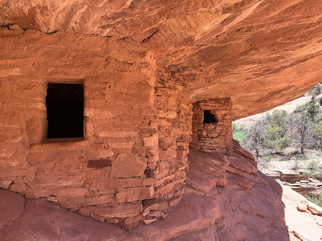
I pulled over to view the Mule Canyon Ruin, and once again had to park my bike and walk in. It was known as the ‘House of Fire’ ruin because of the rock patterning and the light play in the late afternoon. It was technically South Mule Canyon. I met a videographer named Mitch who was from Philadelphia. A couple from San Francisco, whom I had met when I was leaving the Butler Wash ruins had arrived here by motor vehicle at the same time as me. There was a large ravens nest with an impressive stick construction that sat directly above the impressive ruin. Four large babies were demanding food. Mitch was waiting for the afternoon sun to create the fire effect on the rocks at the ruin.
I still had a seven mile and thousand foot ascent ahead of me. It was 3:20 PM. As I was making my way up towards the summit I got a nice little breeze which helped things. I wished a motorist would pull over and offer me a cold water or better yet a cold beer. I kept thinking about the couple last summer outside a Great Falls Montana, who pulled over and stuck a cold can of beer in my hand. I was hoping that the Visitor Center at National Bridges had cold water. A week ago I was freezing in the rain and wet. I knew I'd miss the rain.
I finally made it to the summit and learned about the Mormons whom had originally blasted out the trail. From here until Hite tomorrow it would mostly a downhill into the Colorado River Valley. State Highway 95 intersected with State Route 261, which was my map panel matchline. I was getting close to my destination, and it was 4:38 PM. I’d forgetting to mention that the Utah State Highway system uses a beehive icon behind the numbers on it's state highway signs.
I passed a sign that read ‘No services on state Route 95 for the next 93 miles’. Hopefully the store in Hite would be open tomorrow. I took a right onto State Highway 275 that led Natural Bridges National Monument, where I would be camping tonight. It was four miles off route for a round trip total of eight. I no longer had any cell phone service.
There was a long downhill into the park that I would have to climb back out of tomorrow morning. The visitor center was closed but fortunately there was a drinking fountain with cold water. I gulped and slurped and filled all of my empty bottles. I set up camp in site number three. There was a hexagonal sandbox for my tent. I was covered with brown dust, and it was windy. I sat at the picnic table and edited this report, as I waited for the sun to descend on the horizon.
I took the nine mile scenic drive around the park and viewed Sipapu, Kachina, and Owachomo Bridges. The sun was now low, and I got a good photo of Owachomo Bridge. I had turned off Cyclemeter at the campsite, and hit 500 miles on my odometer during the circuit. It was great to be riding without a helmet or panniers. At the end of the loop I could see Bears Ears far in the distance. I felt filthy, and there was no shower in the campground. I rode back to the visitor center to see if there was running water in the bathrooms. Not only was the men's room open, it had soap dispensers and two working sinks. It was 9PM and no-one was around. I stripped down and took a birdbath. Brown colored water streamed off of me. I used paper towels to dry myself, and one again enjoyed the cold water from the drinking fountain. Refreshed, I rode back to my campsite and cooked myself some dinner.


Comments
Post a Comment